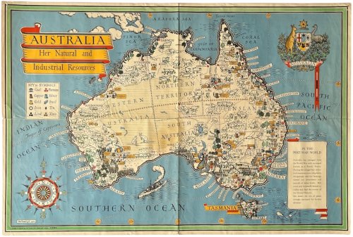
Australia; Her Natural and Industrial Resources.
£1,000.00 GBP • Used
Attractive colour printed map, 500 x 750 mm. old folds, with a little wear to the folds, slight separation to one, and old pin holes to the corners. A little browned to verso but generally a nice ...
Attractive colour printed map, 500 x 750 mm. old folds, with a little wear to the folds, slight separation to one, and old pin holes to the corners. A little browned to verso but generally a nice example of a scarce map. During the Second World War, MacDonald Gill was commissioned by the British Ministry of Information to design colourful pictorial maps showing natural resources of Commonwealth countries to illustrate their economic contribution to the war effort. This map of Australia shows the natural or industrial resources of coal, platinum, copper, silver, gold, steel, iron, tin, lead and zinc. This later issue, which appears to be less common than the 1942 edition, has an updated text in the cartouche reflecting Australia’s new position in the post-war world.
Product Info
Publisher: Printed by Alf Cook, 1946.
Type: Used
Binding: Softcover
Seller Info
MichaelKempBookseller
Address: 19 Adelaide Gardens Sheeness, Kent
Website: https://michaelkemp.co.uk
Country: United Kingdom
